![](/images/other/stat-length.png)
![Trail Walking La Roche-en-Ardenne - Korte van en naar Cielle - Photo](https://media.geolcdn.com/t/1900/400/ext.pjpeg?maxdim=2&url=https%3A%2F%2Fstatic1.geolcdn.com%2Fsiteimages%2Fupload%2Ffiles%2F1553511878bg_sport_marche.png)
Korte van en naar Cielle
jpw-e66
User
![Length](/images/other/stat-length.png)
Length
4.8 km
![Max alt](https://static1.geolcdn.com/siteimages/upload/files/1508320355ic_sort_altitude_max_24dp.png)
Max alt
344 m
![Uphill gradient](https://static1.geolcdn.com/siteimages/upload/files/1508320355ic_sort_den_pos_24dp.png)
Uphill gradient
137 m
![Km-Effort](/images/other/stat-length.png)
Km-Effort
6.7 km
![Min alt](https://static1.geolcdn.com/siteimages/upload/files/1508320355ic_sort_altitude_min_24dp.png)
Min alt
226 m
![Downhill gradient](https://static1.geolcdn.com/siteimages/upload/files/1508320355ic_sort_den_neg_24dp.png)
Downhill gradient
136 m
![Boucle](https://static1.geolcdn.com/siteimages/upload/files/16400158638029165_repeat_loop_refresh_sync_direction_icon.png)
Boucle
Yes
Creation date :
2020-02-22 09:18:56.0
Updated on :
2020-02-22 10:50:04.098
![Walking](https://static1.geolcdn.com/sitytour/trail-icons/101.png)
1h30
Difficulty : Medium
![Scan this QR Code to open this trail in the SityTrail application](https://capi.geolives.com/qq0zvz2zws4bq2lad0pu/sitytour/trails/2342504/qr.png?size=200)
FREE GPS app for hiking
About
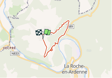
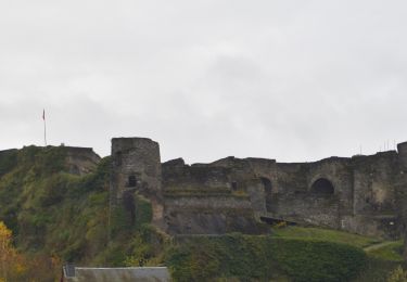
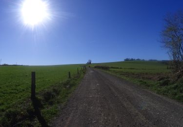
Trail Walking of 4.8 km to be discovered at Wallonia, Luxembourg, La Roche-en-Ardenne. This trail is proposed by jpw-e66.
Description
Korte wandeling - veel langs kleine baan met gemiddeld tot weinig verkeer - 1 maal sterk dalen en 1 maal sterk stijgen - stuk in bos is zeer aangenaam
Positioning
Country:
Belgium
Region :
Wallonia
Department/Province :
Luxembourg
Municipality :
La Roche-en-Ardenne
Location:
La Roche-en-Ardenne
Start:(Dec)
Start:(UTM)
682621 ; 5563121 (31U) N.
Comments
Trails nearby
![Trail Walking La Roche-en-Ardenne - RB-Lu-05 - Au gré de l’Ourthe, la balade des panoramas - Photo](https://media.geolcdn.com/t/375/260/ext.jpg?maxdim=2&url=https%3A%2F%2Fservices.sitytrail.com%2FGeolivesWS%2FDownloadMedia.ashx%3FTrailID%3D179614%26Media%3Ddb2598db-79d7-4bc8-afb7-55d65e443283.jpg)
![Walking Walking](https://static1.geolcdn.com/sitytour/trail-icons/101.png)
RB-Lu-05 - Au gré de l’Ourthe, la balade des panoramas
Walking
Very difficult
(6)
La Roche-en-Ardenne,
Wallonia,
Luxembourg,
Belgium
![](/images/other/stat-length.png)
23 km | 34 km-effort
7h 37min
![](https://static1.geolcdn.com/siteimages/upload/files/16400158638029165_repeat_loop_refresh_sync_direction_icon.png)
Yes
![Trail Walking Rendeux - Arboretum et Ourthe - Photo](https://media.geolcdn.com/t/375/260/114fab54-a809-4035-a129-83d982caf499.jpg&format=jpg&maxdim=2)
![Walking Walking](https://static1.geolcdn.com/sitytour/trail-icons/101.png)
Arboretum et Ourthe
Walking
Medium
(4)
Rendeux,
Wallonia,
Luxembourg,
Belgium
![](/images/other/stat-length.png)
9 km | 12 km-effort
3h 15min
![](https://static1.geolcdn.com/siteimages/upload/files/16400158638029165_repeat_loop_refresh_sync_direction_icon.png)
Yes
![Trail Walking Rendeux - hodister - Photo](https://media.geolcdn.com/t/375/260/e73fbed5-6ae2-4bd7-8844-cc4756518ef2.jpg&format=jpg&maxdim=2)
![Walking Walking](https://static1.geolcdn.com/sitytour/trail-icons/101.png)
hodister
Walking
Easy
(1)
Rendeux,
Wallonia,
Luxembourg,
Belgium
![](/images/other/stat-length.png)
8.8 km | 11.5 km-effort
3h 39min
![](https://static1.geolcdn.com/siteimages/upload/files/16400158638029165_repeat_loop_refresh_sync_direction_icon.png)
Yes
![Trail Walking Manhay - RF-Lu-04 En surplomb de l'ancienne ligne SNCV de l'Aisne : Dochamps - Photo](https://media.geolcdn.com/t/375/260/ext.jpg?maxdim=2&url=https%3A%2F%2Fstatic1.geolcdn.com%2Fsiteimages%2Fupload%2Ffiles%2F1553511878bg_sport_marche.png)
![Walking Walking](https://static1.geolcdn.com/sitytour/trail-icons/101.png)
RF-Lu-04 En surplomb de l'ancienne ligne SNCV de l'Aisne : Dochamps
Walking
Very easy
(4)
Manhay,
Wallonia,
Luxembourg,
Belgium
![](/images/other/stat-length.png)
14.4 km | 19.2 km-effort
4h 5min
![](https://static1.geolcdn.com/siteimages/upload/files/16400158638029165_repeat_loop_refresh_sync_direction_icon.png)
Yes
![Trail Walking Rendeux - promenade de lourthe - Photo](https://media.geolcdn.com/t/375/260/ext.jpg?maxdim=2&url=https%3A%2F%2Fservices.sitytrail.com%2FGeolivesWS%2FDownloadMedia.ashx%3FTrailID%3D338833%26Media%3Dfix__20140824184151.jpg)
![Walking Walking](https://static1.geolcdn.com/sitytour/trail-icons/101.png)
promenade de lourthe
Walking
Difficult
(3)
Rendeux,
Wallonia,
Luxembourg,
Belgium
![](/images/other/stat-length.png)
8.1 km | 11 km-effort
2h 35min
![](https://static1.geolcdn.com/siteimages/upload/files/16400158638029165_repeat_loop_refresh_sync_direction_icon.png)
Yes
![Trail Walking Rendeux - Montaigu - Photo](https://media.geolcdn.com/t/375/260/ext.jpg?maxdim=2&url=https%3A%2F%2Fservices.sitytrail.com%2FGeolivesWS%2FDownloadMedia.ashx%3FTrailID%3D264121%26Media%3De6783db9-1bdf-46f4-876d-878e9e4b81fa.jpg)
![Walking Walking](https://static1.geolcdn.com/sitytour/trail-icons/101.png)
20221118 - TOTEMUS La Roche en Ardenne - 4 Km
Walking
Easy
La Roche-en-Ardenne,
Wallonia,
Luxembourg,
Belgium
![](/images/other/stat-length.png)
4 km | 5.9 km-effort
1h 49min
![](https://static1.geolcdn.com/siteimages/upload/files/16400158638029165_repeat_loop_refresh_sync_direction_icon.png)
Yes
![Mountain bike Mountain bike](https://static1.geolcdn.com/sitytour/trail-icons/202.png)
activity_8670328691
Mountain bike
Difficult
La Roche-en-Ardenne,
Wallonia,
Luxembourg,
Belgium
![](/images/other/stat-length.png)
30 km | 41 km-effort
2h 48min
![](https://static1.geolcdn.com/siteimages/upload/files/16400158638029165_repeat_loop_refresh_sync_direction_icon.png)
Yes
![Trail On foot La Roche-en-Ardenne - 7. Hives - Photo](https://media.geolcdn.com/t/375/260/4f580847-be8f-4b9e-a165-df244a253ac4.jpeg&format=jpg&maxdim=2)
![On foot On foot](https://static1.geolcdn.com/sitytour/trail-icons/100.png)
7. Hives
On foot
Easy
La Roche-en-Ardenne,
Wallonia,
Luxembourg,
Belgium
![](/images/other/stat-length.png)
11.6 km | 15.5 km-effort
3h 31min
![](https://static1.geolcdn.com/siteimages/upload/files/16400158638029165_repeat_loop_refresh_sync_direction_icon.png)
Yes